


")


///
Accuracy
Kayrros scientists have authored numerous articles in top-tier, peer-reviewed academic journals. These include:
Global Assessment of Oil and Gas Methane Ultra-Emitters. Science.
Global patterns of daily CO² emissions reductions in the first year of COVID-19. Nature Geoscience.
Comparing national greenhouse gas budgets reported in UNFCCC inventories against atmospheric inversions.
Digital twinning of all forest and non-forest trees at national level via deep learning.
Proceedings of the National Academy of Sciences.
Global Tracking and Quantification of Oil and Gas Methane Leaks from Recurrent Sentinel-2 Imagery.
Environmental Science & Technology
EU carbon emissions from regulated sectors:
Kayrros daily measurements vs. lagged official annual estimates
Cumulative Kayrros Patent Applications
A list of papers citing our results can be found
Kayrros partners with leading research institutions around the world and has filed numerous technological patents.
Kayrros near-realtime data have consistently proven to be a highly accurate precursor of official data releases whenever available.
For example, for two consecutive years, Kayrros daily, near-realtime measurements of European carbon emissions have matched EU lagged annual data with an accuracy greater than 98.5%.
Coverage
Kayrros is a one-stop shop for all climate measurements that matter
Kayrros has mapped all the physical assets that matter the most on a global scale and measures all the parameters that are relevant to the energy transition, ensuring the best and broadest coverage available of energy and the environment.
In processing and analyzing satellite imagery, Kayrros leverages a fast-growing proprietary database of more than 3 million physical assets, to cover all dimensions of the energy transition.
Kayrros measurements include new production capacity, production volumes, flows, inventories, intermediate and final consumption and associated greenhouse gas emissions and pollutants for all forms of energy and associated materials. Kayrros also tracks energy infrastructure growth and models and measures physical risks and damages associated with climate change
.
Daily measurements across tens of parameters and millions of assets create the best possible independent coverage of energy and environment.
Value
///
///
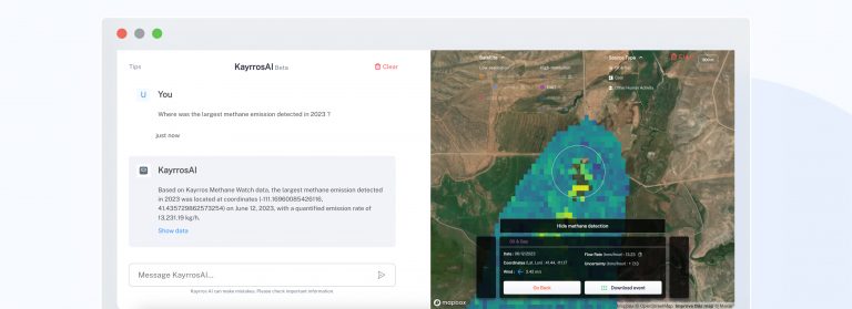
Kayrros releases KayrrosAI, first-of-its-kind methane-focused RAG LLM at COP29
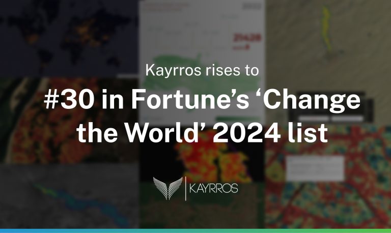
Kayrros rises to #30 in Fortune’s ‘Change the World’ 2024 list
The Global Methane Pledge, Three Years On: Partial Progress Report
List of papers citing our results
[1] T. Dagobert, R. Grompone von Gioi, C. de Franchis, and C. Hessel, “Detection and Interpretation of Change in Registered Satellite Image Time Series,” Image Process. Line, vol. 12, pp. 625–651, Dec. 2022, doi: 10.5201/ipol.2022.416.
[2] R. Akiki, C. de Franchis, G. Facciolo, J.-M. Morel, and R. Grandin, “Phase Unwrapping using a Joint CNN and SQD-LSTM Network,” Image Process. Line, vol. 12, pp. 378–388, Oct. 2022, doi: 10.5201/ipol.2022.425.
[3] T. Lauvaux et al., “Global assessment of oil and gas methane ultra-emitters,” Science (80-. )., vol. 375, no. 6580, pp. 557–561, Feb. 2022, doi: 10.1126/science.abj4351.
[4] Z. Deng et al., “Comparing national greenhouse gas budgets reported in UNFCCC inventories against atmospheric inversions,” Earth Syst. Sci. Data, vol. 14, no. 4, pp. 1639–1675, Apr. 2022, doi: 10.5194/essd-14-1639-2022.
[5] Z. Liu et al., “Global patterns of daily CO2 emissions reductions in the first year of COVID-19,” Nat. Geosci., vol. 15, no. 8, pp. 615–620, Aug. 2022, doi: 10.1038/s41561-022-00965-8.
[6] N. L. Nguyen, J. Anger, A. Davy, P. Arias, and G. Facciolo, “Self-Supervised Super-Resolution for Multi-Exposure Push-Frame Satellites,” in 2022 IEEE/CVF Conference on Computer Vision and Pattern Recognition (CVPR), Jun. 2022, pp. 1848–1858, doi: 10.1109/CVPR52688.2022.00190.
[7] T. Ehret et al., “Global Tracking and Quantification of Oil and Gas Methane Emissions from Recurrent Sentinel-2 Imagery,” Environ. Sci. Technol., vol. 56, no. 14, pp. 10517–10529, Jul. 2022, doi: 10.1021/acs.est.1c08575.
[8] R. Grompone von Gioi, C. Hessel, T. Dagobert, J.-M. Morel, and C. de Franchis, “Cloud detection by inter-band parallax and a-contrario validation,” in ISPRS Annals of Photogrammetry, Remote Sensing and Spatial Information Sciences, 2022, vol. 5, no. 3, pp. 39–46, doi: 10.5194/isprs-Annals-V-3-2022-39-2022.
[9] R. Marí, T. Ehret, J. Anger, C. de Franchis, and G. Facciolo, “L1B+: a Perfect Sensor Localization Model for Simple Satellite Stereo Reconstruction From Push-Frame Image Strips,” in ISPRS Annals of the Photogrammetry, Remote Sensing and Spatial Information Sciences, 2022, vol. 5, no. 1, pp. 137–143, doi: 10.5194/isprs-annals-V-1-2022-137-2022.
[10] E. Ouerghi et al., “Automatic methane plumes detection in time series of Sentinel-5P L1B images,” in ISPRS Annals of the Photogrammetry, Remote Sensing and Spatial Information Sciences, 2022, vol. 5, no. 3, pp. 147–154, doi: 10.5194/isprs-Annals-V-3-2022-147-2022.
[11] N. L. Nguyen, J. Anger, A. Davy, P. Arias, and G. Facciolo, “Self-Supervised Push-Frame Super-Resolution With Detail-Preserving Control And Outlier Detection,” in International Geoscience and Remote Sensing Symposium (IGARSS), 2022, pp. 131–134, doi: 10.1109/IGARSS46834.2022.9883593.
[12] T. Ehret, A. De Truchis, M. Mazzolini, J.-M. Morel, and G. Facciolo, “Automatic Methane Plume Quantification Using Sentinel-2 Time Series,” in International Geoscience and Remote Sensing Symposium (IGARSS), 2022, pp. 1955–1958, doi: 10.1109/IGARSS46834.2022.9884134.
[13] F. Marchesoni-Acland, M. D’Autume, G. Facciolo, C. de Franchis, J.-M. Morel, and E. Meinhardt-Llopis, “Interactive Segmentation for Shape From Shading over HR SAR images,” in International Geoscience and Remote Sensing Symposium (IGARSS), 2022, pp. 975–978, doi: 10.1109/IGARSS46834.2022.9884193.
[14] R. Akiki, J. Anger, C. de Franchis, G. Facciolo, J.-M. Morel, and R. Grandin, “Improved Sentinel-1 IW Burst Stitching Through Geolocation Error Correction Considerations,” in International Geoscience and Remote Sensing Symposium (IGARSS), 2022, pp. 3404–3407, doi: 10.1109/IGARSS46834.2022.9883116.
[15] T. Ehret, S. Lajouanie, V. Lefrançois, and C. de Franchis, “Automatic Monitoring of Water Level in Small Lakes Using Planetscope,” in International Geoscience and Remote Sensing Symposium (IGARSS), 2021, pp. 3356–3359, doi: 10.1109/IGARSS47720.2021.9554431.
[16] R. Marí, C. de Franchis, E. Meinhardt-Llopis, and G. Facciolo, “Automatic Stockpile Volume Monitoring Using Multi-View Stereo From SkySat Imagery,” in International Geoscience and Remote Sensing Symposium (IGARSS), 2021, pp. 4384–4387, doi: 10.1109/IGARSS47720.2021.9554482.
[17] R. Marí, C. de Franchis, E. Meinhardt-Llopis, J. Anger, and G. Facciolo, “A Generic Bundle Adjustment Methodology for Indirect RPC Model Refinement of Satellite Imagery,” Image Process. Line, vol. 11, pp. 344–373, Nov. 2021, doi: 10.5201/ipol.2021.352.
[18] N. L. Nguyen, J. Anger, A. Davy, P. Arias, and G. Facciolo, “Self-supervised multi-image super-resolution for push-frame satellite images,” in 2021 IEEE/CVF Conference on Computer Vision and Pattern Recognition Workshops (CVPRW), Jun. 2021, pp. 1121–1131, doi: 10.1109/CVPRW53098.2021.00123.
[19] R. Grompone von Gioi, C. Hessel, T. Dagobert, J.-M. Morel, and C. de Franchis, “Ground Visibility in Satellite Optical Time Series Based on A Contrario Local Image Matching,” Image Process. Line, vol. 11, pp. 212–233, Jul. 2021, doi: 10.5201/ipol.2021.342.
[20] R. Akiki, R. Mari, C. de Franchis, J.-M. Morel, and G. Facciolo, “Robust Rational Polynomial Camera Modelling for SAR and Pushbroom Imaging,” in International Geoscience and Remote Sensing Symposium (IGARSS), 2021, pp. 7908–7911, doi: 10.1109/igarss47720.2021.9554583.
[21] R. Akiki, R. Grandin, C. de Franchis, G. Facciolo, and J.-M. Morel, “A Comparative Study of Deramping Techniques for Sentinel-1 TOPS in the Context of Interferometry,” in International Geoscience and Remote Sensing Symposium (IGARSS), Jul. 2021, pp. 3372–3375, doi: 10.1109/IGARSS47720.2021.9553049.
[22] N. L. Nguyen, J. Anger, A. Davy, P. Arias, and G. Facciolo, “Proba-V-Ref: Repurposing the Proba-V Challenge for Reference-Aware Super Resolution,” in International Geoscience and Remote Sensing Symposium (IGARSS), 2021, pp. 3881–3884, doi: 10.1109/IGARSS47720.2021.9554479.
[23] J. Anger, T. Ehret, and G. Facciolo, “Parallax Estimation for Push-Frame Satellite Imagery: Application To Super-Resolution and 3D Surface Modeling From SkySat Products,” in International Geoscience and Remote Sensing Symposium (IGARSS), 2021, pp. 2679–2682, doi: 10.1109/IGARSS47720.2021.9554340.
[24] E. Ouerghi et al., “Detection of Methane Emissions Using Pattern Recognition,” in International Geoscience and Remote Sensing Symposium (IGARSS), 2021, pp. 3773–3776, doi: 10.1109/IGARSS47720.2021.9553897.
[25] C. Hessel, C. de Franchis, G. Facciolo, and J.-M. Morel, “A Global Registration Method for Satellite Image Series,” in International Geoscience and Remote Sensing Symposium (IGARSS), Jul. 2021, pp. 3121–3124, doi: 10.1109/IGARSS47720.2021.9554786.
[26] C. Williams, T. Dagobert, C. de Franchis, J.-M. Morel, and C. Hessel, “Fast Accurate Supervised Cloud Annotation,” in International Geoscience and Remote Sensing Symposium (IGARSS), Jul. 2021, pp. 3237–3240, doi: 10.1109/IGARSS47720.2021.9554213.
[27] M. Rodriguez et al., “A CNN Cloud Detector for Panchromatic Satellite Images,” in International Geoscience and Remote Sensing Symposium (IGARSS), Jul. 2021, pp. 4964–4967, doi: 10.1109/IGARSS47720.2021.9554059.
[28] T. Dagobert, R. Grompone von Gioi, C. Hessel, J.-M. Morel, and C. de Franchis, “Change Analysis in Registered Satellite Image Time Series,” in International Geoscience and Remote Sensing Symposium (IGARSS), Jul. 2021, pp. 4360–4363, doi: 10.1109/IGARSS47720.2021.9554700.
[29] E. Ouerghi et al., “Detection of methane plumes in hyperspectral images from Sentinel-5P by coupling anomaly detection and pattern recognition,” in ISPRS Annals of the Photogrammetry, Remote Sensing and Spatial Information Sciences, 2021, vol. 5, no. 3, pp. 81–87, doi: 10.5194/isprs-annals-V-3-2021-81-2021.
[30] M. Colom, T. Dagobert, C. de Franchis, R. Grompone von Gioi, C. Hessel, and J.-M. Morel, “Using the IPOL Journal for Online Reproducible Research in Remote Sensing,” IEEE J. Sel. Top. Appl. Earth Obs. Remote Sens., vol. 13, pp. 6384–6390, 2020, doi: 10.1109/JSTARS.2020.3032100.
[31] T. Dagobert, R. Grompone von Gioi, C. de Franchis, J.-M. Morel, and C. Hessel, “Cloud Detection by Luminance and Inter-band Parallax Analysis for Pushbroom Satellite Imagers,” Image Process. Line, vol. 10, pp. 167–190, Nov. 2020, doi: 10.5201/ipol.2020.271.
[32] T. Dagobert, R. Grompone von Gioi, J.-M. Morel, and C. de Franchis, “Temporal Repetition Detector for Time Series of Spectrally Limited Satellite Imagers,” Image Process. Line, vol. 10, pp. 62–77, Jun. 2020, doi: 10.5201/ipol.2020.245.
[33] A. Tadros, S. Drouyer, R. Grompone von Gioi, and L. Carvalho, “Oil Tank Detection in Satellite Images via a Contrario Clustering,” in International Geoscience and Remote Sensing Symposium (IGARSS), 2020, pp. 2233–2236, doi: 10.1109/IGARSS39084.2020.9323249.
[34] A. Tadros, S. Drouyer, R. Grompone von Gioi, G. Facciolo, and L. Carvalho, “Circular-Shaped Object Detection in Low Resolution Satellite Images,” in ISPRS Annals of the Photogrammetry, Remote Sensing and Spatial Information Sciences, 2020, vol. 5, no. 2, pp. 901–908, doi: 10.5194/isprs-annals-V-2-2020-901-2020.
[35] M. D’Autume, A. Perry, J.-M. Morel, E. Meinhardt-Llopis, and G. Facciolo, “Stockpile Monitoring Using Linear Shape-From-Shading on Planetscope Imagery,” in ISPRS Annals of the Photogrammetry, Remote Sensing and Spatial Information Sciences, 2020, vol. 5, no. 2, pp. 427–434, doi: 10.5194/isprs-annals-V-2-2020-427-2020.
[36] J. Anger, T. Ehret, C. de Franchis, and G. Facciolo, “Fast and Accurate Multi-Frame Super-Resolution of Satellite Images,” in ISPRS Annals of the Photogrammetry, Remote Sensing and Spatial Information Sciences, 2020, vol. 5, no. 1, pp. 57–64, doi: 10.5194/isprs-annals-V-1-2020-57-2020.
[37] R. Grompone von Gioi, C. Hessel, T. Dagobert, J.-M. Morel, and C. de Franchis, “Temporal Repetition Detection for Ground Visibility Assessment,” in ISPRS Annals of the Photogrammetry, Remote Sensing and Spatial Information Sciences, 2020, vol. 5, no. 2, pp. 829–835, doi: 10.5194/isprs-annals-V-2-2020-829-2020.
[38] S. Drouyer and C. de Franchis, “Parking Occupancy Estimation on Sentinel-1 Images,” in ISPRS Annals of the Photogrammetry, Remote Sensing and Spatial Information Sciences, 2020, vol. 5, no. 2, pp. 821–828, doi: 10.5194/isprs-annals-V-2-2020-821-2020.
[39] C. Hessel, R. Grompone von Gioi, J.-M. Morel, G. Facciolo, P. Arias, and C. de Franchis, “Relative Radiometric Normalization Using Several Automatically Chosen Reference Images for Multi-Sensor, Multi-Temporal Series,” in ISPRS Annals of the Photogrammetry, Remote Sensing and Spatial Information Sciences, 2020, vol. 5, no. 2, pp. 845–852, doi: 10.5194/isprs-annals-V-2-2020-845-2020.
[40] S. Drouyer and C. de Franchis, “Highway Traffic Monitoring on Medium Resolution Satellite Images,” in International Geoscience and Remote Sensing Symposium (IGARSS), Jul. 2019, pp. 1228–1231, doi: 10.1109/IGARSS.2019.8899777.
[41] P. Chiberre, E. Meinhardt-Llopis, C. de Franchis, and G. Facciolo, “3D Modeling of Earth’s Surface: Study of the Antarctica,” in International Geoscience and Remote Sensing Symposium (IGARSS), Jul. 2019, pp. 1088–1091, doi: 10.1109/IGARSS.2019.8900179.
[42] T. Dagobert, J.-M. Morel, C. de Franchis, and R. Grompone von Gioi, “Visibility Detection in Time Series of Planetscope Images,” in International Geoscience and Remote Sensing Symposium (IGARSS), Jul. 2019, pp. 1673–1676, doi: 10.1109/IGARSS.2019.8898892.
[43] J. Anger, C. de Franchis, and G. Facciolo, “Assessing the Sharpness of Satellite Images: Study of the Planetscope Constellation,” in International Geoscience and Remote Sensing Symposium (IGARSS), Jul. 2019, pp. 389–392, doi: 10.1109/IGARSS.2019.8900526.
[44] R. Mari, C. de Franchis, E. Meinhardt-Llopis, and G. Facciolo, “To bundle adjust or not: A comparison of relative geolocation correction strategies for satellite multi-view stereo,” in International Conference on Computer Vision Workshop, ICCVW, 2019, pp. 2188–2196, doi: 10.1109/ICCVW.2019.00274.