In a new algorithmic alert system, combining advanced mathematics and satellite imagery eliminates the blind spots of HV powerlines
Picture vast stretches of powerlines, rolling through cities and forests as one of the lifelines of our modern society. Now imagine if it were possible to monitor the safety of the entire network with the click of a button, with satellite imagery and AI working silently in concert to catch emerging risks from a crane to a broken tree branch, a common California wildfire catalyst. Kayrros is bringing this vision to the market by unveiling a new algorithmic alert system that monitors high-voltage powerlines from the lens of a satellite, allowing thousands of miles of infrastructure to be covered in just one shot.
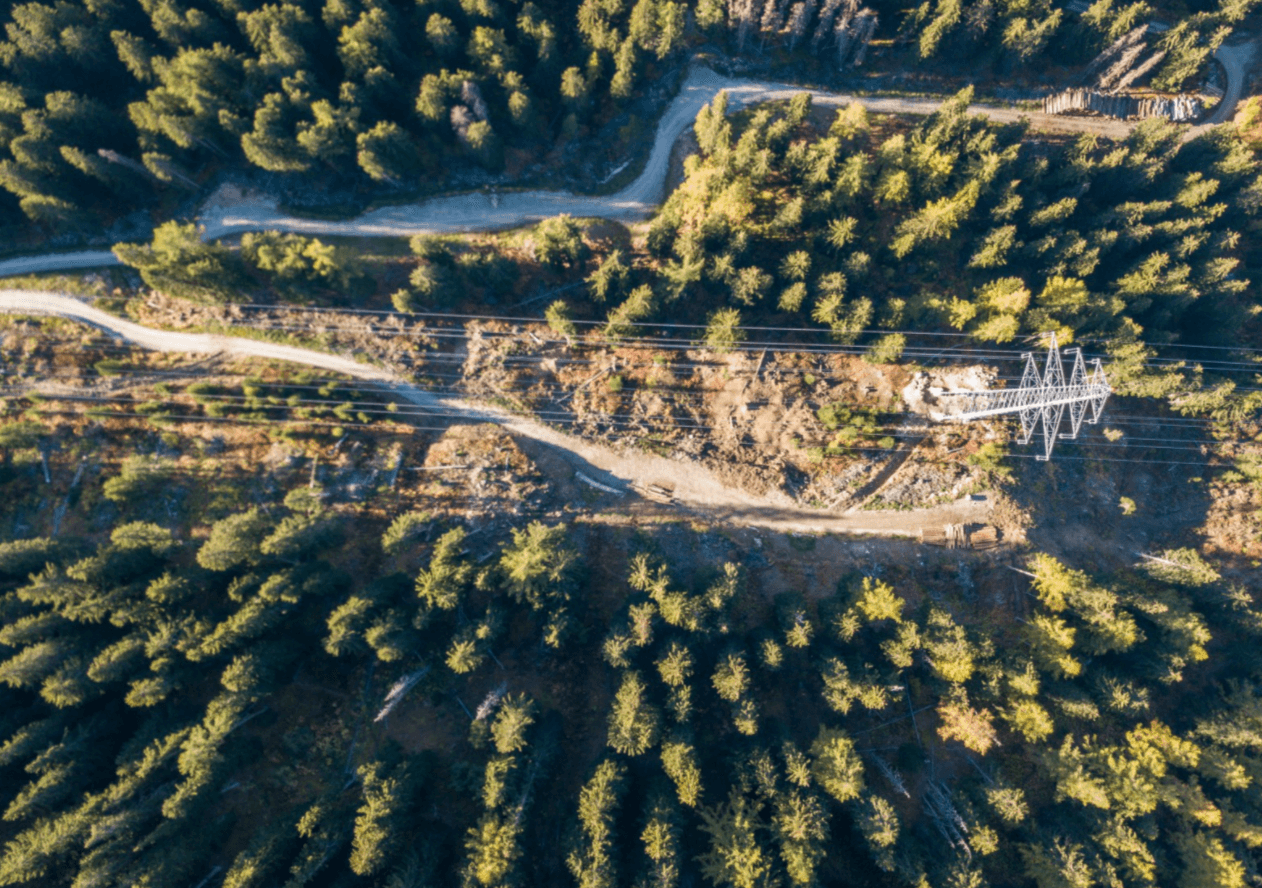
The vastness renders the entire length of a powerline subject to blind spots for operators; and given the length of the lines, frequent manual monitoring is nearly impossible but is a crucial necessity. Imperative to the safety and the reliability of HV lines is for them to maintain a safe distance from other objects to avoid the electrical arcing that can trigger a shutdown of the lines, risks of electrocution, or even wildfires. But the lens of a satellite can be focused to catch the blind spots, and Kayrros combines the resulting imagery with computational algorithms and 3D mapping to monitor two key risk areas: metallic structures and growth of vegetation.
From thousands of miles above the Earth, cities and suburbs appear as grids, split by a framework defined by avenues and parks. However, despite an area’s permanent metallic makeup, new “temporary” structures appear constantly — cars, cranes or even a circus tent. For powerlines, the presence of these temporary structures poses a risk; should a crane veer too close to an HV line there is an operational hazard with a high safety threat, particularly to the personnel operating the crane. As part of its goal to bring transparency to energy, Kayrros has now developed an algorithm that works in tandem with synthetic aperture radar (SAR) to filter images to autonomously separate temporary metal structures from permanent infrastructure. If the new structures are then confirmed to be too close to any HV lines, a team can be sent to the precise location within minutes to resolve the situation.
As the satellite lens moves beyond urban frameworks, grid foundations transform into vast natural landscapes and areas of forest, and the risks surrounding HV lines become somewhat different. Vegetation growing too close to lines can trigger a shutdown or fire, and areas of risk are often difficult to monitor frequently due to their isolated location. The Kayrros approach combines optical satellite imagery and 3D mapping to monitor powerlines in open landscapes and dense forests, catching signs of vegetation growing in dangerous proximity to the lines. Data scientists do this by taking two optical satellite images from slightly different angles and using them to construct a digital 3D model of the area’s topography, allowing HV line operators to investigate precise details of any vegetation before deciding whether to dispatch a crew to the location. Such visibility on the network is crucial when you consider that the most destructive wildfire in California was caused by a spark on a PG&E powerline. Imagine being able to prevent fires of this scale in the future.
Satellite imagery and advanced data science are bringing greater transparency across the energy chain, from generation to delivery. Kayrros is the leader in its field, harnessing all forms of data — from conventional to alternative — to bring greater understanding, reliability, and safety to energy supply. The latest innovations brought by the Kayrros global automated alert system bring unprecedented visibility to HV lines, giving operators the viewpoint they don’t have on the ground. This will make operations smoother, powerlines safer, and costs lower. The future is now.